Amidst the dynamic landscape of Te Wahipounamu National Park
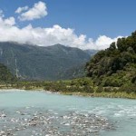
In the Island Nation of New Zealand, located in the Southwest Pacific Ocean, are three main Islands – the North Island, the South Island and the Steward Island along with other small offshore Islands.
The South Island, flanked by Cook Strait in the north, the Tasman Sea in the south and the Pacific Ocean in the south and east. On the southwest of this Island is the World Heritage Site of Te Wahipounamu, spread across 26,000 square kilometers, including the coast of Te Wahipounamu.
When to visit
South Island has a temperate climate. The areas in the south and south-west part of the country are more wet and cooler. The Ocean moderates the temperature in South Island, especially that in the west and south, resulting in a cool, temperate climate.
The average temperature of this Island is about 8 degree Celsius. July is the coldest month while [...]
The Moai of Rapa Nui Easter Island
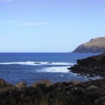
Known locally as Rapa Nui, the Easter Island is at 3,510 kilometers to the west of Chile in the South Pacific Ocean.
This 163.6 kilometer square Island was named Easter Island by the Dutch Admiral Roggeveen who came upon this Island on the Easter Day in 1722.
It is pretty much populated given its isolated location.
When to go
The Rapa Nui Island experiences a subtropical marine climate. The hottest months are January and February with maximum temperature is around 28 degree Celsius on an average. In winters, the temperatures range from 14 degree Celsius to 22 degree Celsius. While most of the rainfall occurs in April-May, be prepared for a downpour at anytime of the year.
The months of July and August, though chilly, are a good hiking season. It’s from January to March that the tourists flock the Rapa Nui Island.
How to go
From Chile, Lan [...]
Peter Island – Sandy White Beach
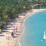
The British Virgin Islands, located 1200 miles to the southeast of Miami and 70 miles east of Puerto Rico, is home to many beautiful beaches. One of them is the White Bay Beach, at the Peter Island here, which runs along the Sir Francis Drake Channel.
The Island is five miles south of Tortola. It is the fifth largest Island in British Virgin Islands, and the largest private one, covering an area of about 1800 acres.
Peter Island was named after Peiter Adriensen, brother of Abraham Adriensen – Tortola’s patron under the Dutch West India Company in the early 17th century.
On the south, or at the back-side of Peter Island is the secluded beach of White Bay.
When to visit
With a sub-tropical climate, the British Virgin Islands are good in anytime of the year. The months from September to December are the wettest months here and that of February [...]
Lanikai Beach – Epitomizing South Pacific Paradise
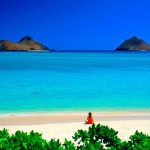
The Lanikai Beach in one of the many pretty beaches of the Hawaii and like all of them is simply spectacular and with no public facility developed on the beach, is all the more charming place to visit. The pure crystal clear water brings tourists here who are keen on snorkeling. Lovers of other water sports like surfing, kayaking, paddling etc need not be disappointed as the sea here is fit for everything. Not far away are places that make for good excursions and hence giving you diversions that make you want to come back to the beach again for relaxations and some rest.
Location
The Lanikai Beach is among the most popular beaches of the beaches in the Hawaii. In the Hawaiian language, Lanikai means “heavenly sea” and the Lanikai Beach definitely stands up to the meaning of its name.
Stretching over half a mile, the Lanikai Beach is located [...]
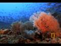
In The Whale Reserve
Common Info
Azores is a Portuguese archipelago located in the Atlantic Ocean about 1500 kilometres from Lisbon. Monchiquet Islet on Flores Island in the western part of the Azores is the western most tip of Europe. They were discovered way back in 1427 by Portuguese explorers and were colonised later by people of Portuguese and Flemish descent. The nine major Azorean islands and the Formigas in the eastern part of the Azorian archipelago extend for more than 600 kilometres and cover a total area of 2,346 square kilometres. Mount Pico on Pico Island is the highest point on the Azores (in fact the highest in Portugal). Azores also feature an immense exclusive economic zone. Azores comprise Sao Miguel Island, Faial Island, Sao Jorge Island, Terceira Island, Flores Island, Santa Maria Island, Corvo Island, Graciosa Island and Terceira Island. [...]
Birds Of Heaven Called Mauritius
Country Info
Located in Indian Ocean off the eastern coast of Africa, Mauritius is a small island nation with an area of 2,040 square kilometers. It is located almost 900 kilometres east of Madagascar. Besides the Mauritius island, the country also includes Cargados Carajos, Rodrigues and Agalega Islands. Mauritius is also part of the Mascarene islands. The country is surrounded by coral reefs. National capital is Port Loius. Currency is Mauritian Rupee. Mauritius was once home to the now extinct Dodo birds. Mauritius was proclaimed a Republic in 1992.
Geography
The Mauritius archipelago was formed as a result of undersea volcanic eruptions millions of years ago. The island is formed around a plateau which rises towards the southwest. Piton de la Petite Rivière Noire is the highest peak at 2,717 feet.
Casela
Mauritius is a travellers’ [...]
Hike 11 Miles To Enjoy Na Pali Coast In Hawaii
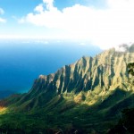
The Na Pali Coast is a small part of the once shield volcano that is said to have risen more than 5 miles from the sea floor to the summit. Like the other islands of Hawaii, the Island of Kauai was originally a plume of magma, called a hot spot. When the volcanic fires cooled down, the island shifted due to tectonic movements and water cooled down. Rains in parts of Na Pali created deep valleys and waterfalls over the precipices. The strong and giant winter waves that exploded against the basalt cliffs created unstable slopes.
Na Pali that we have today with its sinks of valleys, fluted walls, and the sharp ridges is a consequence of these tectonic activities.
Where is it
Napali Coast is the name given to the 15 miles of mountainous shore lines on the northwest of Kauai Islands in Hawaii. Napali, in Hawaiian means the Cliffs. Standing true [...]
Bora Bora Island – A Pearl Of South Pacific
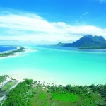
The turquoise water of the lagoons, an exhilarating ride over it by canoes, jet ski or a catamaran sailboat, a sunset view that takes your breath away, cruising along the panoramic views, a vibrant marine life that you can come close to by snorkeling and diving and the souvenir shops that allow you take home the memoirs from here, in short, this is the much acclaimed Bora Bora Island.
The name Bora Bora comes from the Tahitian word Pora Pora, which means “first born”. Legends describe it as the first island to rise when the Supreme God Taaroa fished it out of the waters after the creation of Havai’i. When Captain Cook heard the name, he mistook Pora Pora for Bora Bora and that’s how the name gained currency and is used till date.
As per an early transcription found in 18th and the 19th century accounts, the name of the Island is recorded [...]
A Picturesque Escape Bora Bora – Matira Beach
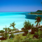
The Bora Bora Island is home to many exotic beaches, ideal for a tranquil as well as fun filled holiday. The Matira Beach on this Island is, however, is supposed to be the best beach here.
Location
On the leeward group of the Society Islands Archipelago of French Polynesia, in the South Pacific Ocean is the Bora Bora Island. The Island stretches to about 18 miles and is surrounded by a lagoon and a barrier reef.
On the south end of this Island is the Matira Beach, a mile long beach that is among the best beaches of o f this Island. The starting point of this beach is the well known resort of Hotel Bora Bora from where it goes around the south of the Island to the Matira Point and extends 3 kilometers ahead to the Club Med. Lined up along the beach are a number of resorts where you can stay.
When to go
The Bora Bora Island has a tropical climate [...]
Snorkeling In The Far-Off Anse La Roche
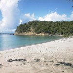
In the Windward Islands of the eastern Caribbean, to its southern end are the Islands of Grenada, Carriacou and Petite Martinique. Carriacou Island is in fact the southernmost part of all the Grenadines which groups about 200 islands.
Unlike the other Islands, Carriacou is pretty much untouched by too much tourism and is know fro its unspoiled tranquil beaches. One such beach here is the beach of Anse La Roche, to the north of Grenada by 23 miles and 90 miles north of Venezuela.
Weather
The Carriacou Island is just about 830 miles from the equator. This gives the Island a tropical climate. Most of the rains occur in the months from June to November and the rest of the year can be categorized as dry season.
However, it’s sunny and bright even in the rainy season. The rains are heavy but they have a short duration and mostly occur at night.
In [...]